004 Intermediate Directions
👩🏫 Teacher’s Guide
Objective
Read a map and use its labels, directions, or grid to locate places.
Vocabulary
north, east, compass rose
Suggested time
30-40 minutes, with optional practice across the week.
Teaching Notes
- Model one question by naming the relevant row, label, or statement. Have students explain the evidence for a second answer before working independently.
- Introduce the study resource before assigning questions. Students can answer using this lesson without opening the source book.
- Use questions 1-4 for guided practice and the remaining questions for independent practice or discussion. Open responses may use different wording if the evidence supports them.
- Check the activity against its stated constraints and the answer bank. Revisit a missed concept before adding a new one.
🧒 Student Worksheet
Concept and Helping Material
A map shows a place from above. It helps us describe where things are. Read its title first. Then use its labels and key. On this practice map, the top is north. The bottom is south. East is right and west is left. Northeast lies between north and east. Southeast, southwest, and northwest are also intermediate directions. A direction describes one place in relation to another.
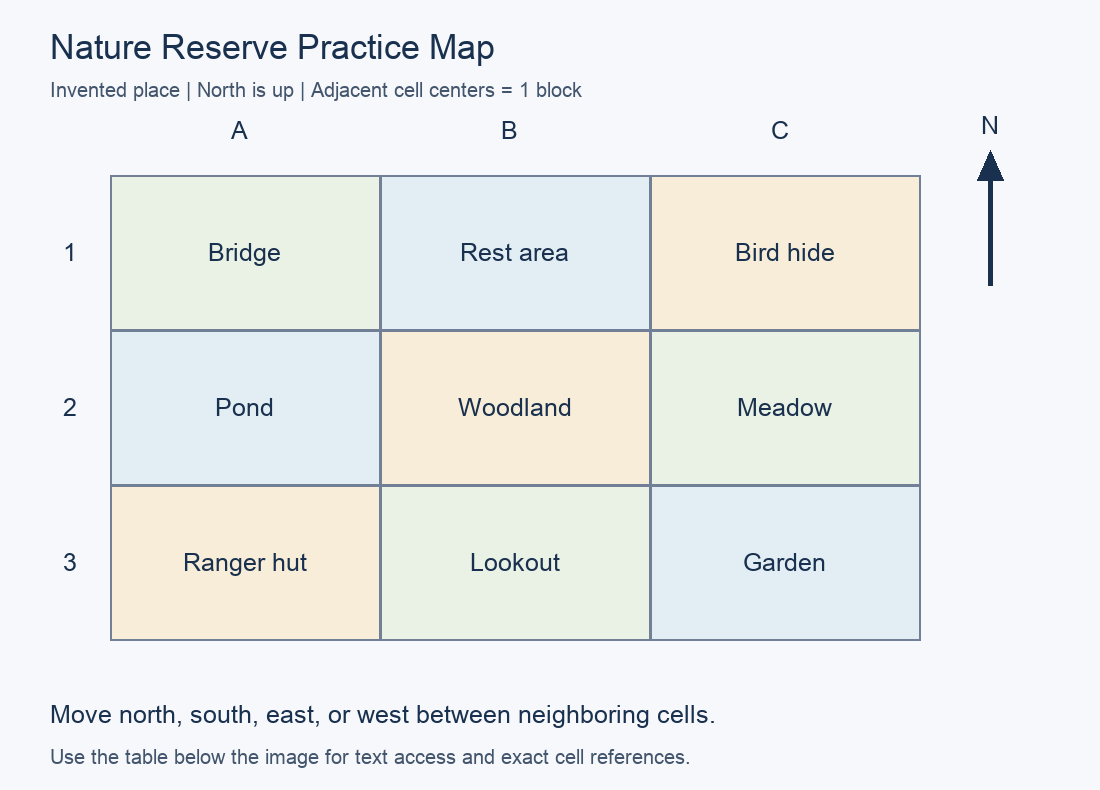
Study Resource: Nature Reserve Practice Map
This is an invented practice place. North is up. Columns A, B, C run west to east. Rows 1, 2, 3 run north to south. Each cell has one place. Adjacent cell centers are one block apart. Walk only north, south, east, or west.
| Row / Column | A | B | C |
|---|---|---|---|
| 1 | Bridge | Rest area | Bird hide |
| 2 | Pond | Woodland | Meadow |
| 3 | Ranger hut | Lookout | Garden |
Vocabulary and Definition
- - the direction toward the North Pole
- - the direction opposite west
- - a map symbol that shows directions
Words to Learn
, ,
Sentences to Fill In
- The term for the direction toward the North Pole is .
- The term for the direction opposite west is .
- The term for a map symbol that shows directions is .
🧪 Think & Respond Q&A
What place is in cell A1 on the Nature Reserve practice map?
What place is in cell C2 on the Nature Reserve practice map?
What cell contains Woodland?
Which place is immediately east of Bridge?
In which intermediate direction is Bridge from Woodland?
In which intermediate direction is Garden from Woodland?
Give a two-block route from Bridge to Bird hide.
Why does this map need labels?
On this map, is Bridge in the same row or the same column as Bird hide?
What information would you need to find the real distance in meters between two places?
Which lesson word means "the direction toward the North Pole"?
Which lesson word means "the direction opposite west"?
Which lesson word means "a map symbol that shows directions"?
Hands-On Experiment or Activities
What You Need: Paper, pencil, and nine small counters.
What You Do:
- Copy the Nature Reserve practice map. Mark A1 with a counter. Ask a partner to give three legal moves and follow them. Write the start, moves, and final cell.
- Check the route by tracing each move. Then describe a different route to the same destination.
- Revise one part of your work after checking it against the lesson evidence.
Think and Talk: What evidence supports one choice in your work?
Reflection
- Which idea can you explain now?
- What would you still need to learn about a real place?
Teacher Check
Check accurate use of the study resource, correct vocabulary or units, and a reason supported by evidence. For open activities, accept more than one result when it follows the instructions. The companion CSV contains the same numbered Q&A bank shown above.
Curriculum Reference
Scope alignment: Evan-Moor, Daily Geography Practice, Grade 3, Week 4. Teacher lesson begins on printed page 18 (PDF page 20). The explanations, practice data, diagrams, activities, and questions in this lesson are original. Fictional datasets are labeled in their study resources.